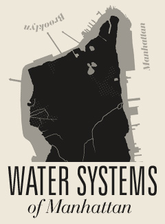
 Water Systems of Manhattan
Beneath New York’s lattices of concrete, iron and landfill lie dozens of organic waterways. Using data from an 1865 sanitation map and contemporary satellite photographs, this projection depicts Manhattan as a vascular organ, whose obscure operation has had a powerful bearing on the fate of the city.
![]()
Please Install Adobe Flash Player to View This Map


cartography by ZACK SULTAN, development by STEVE DETTLING, research by BRADLEY HOPE & ALEXANDRA ATIYA, underground photography by STEVE DUNCAN
General Egbert Ludovicus Viele, a civil engineer and veteran of the Mexican-American war, released his seminal work in 1865. It was a painstakingly accurate topography of the island of Manhattan, which by that time had already been radically altered by development. It revealed in detail the network of underground channels, springs and rivers that crisscrossed the island, and charted the path of every sewer tunnel and pipeline undergirding the streets.
 Icons indicate reporting, both factual and mythic, we have accumulated. Send your data points to info@nymoon.com
Viele’s original aim was to remedy what the New York Times referred to as the city’s “drainage deficiencies” — the tendency for rivers of human and animal feces to collect in impoverished districts, because land developers indiscriminately filled underground waterways.
“Every one must be filled with astonishment that New-York has not had an actual mediaeval plague,” wrote the Times in 1874. “Had New-York been an inland town, and had the inhabitants been forced to live as Parisians do, principally on bread and onions, there would have been in our records a Black Death as terrible as that which devastated Europe in the days of Boccaccio.”
Created for the department of sanitation, the map was a reminder that natural water systems, entombed beneath modern accumulations, hidden from view, could still have monumental effects on the functioning of city life. Indeed, structural engineers and city planners continue to consult the Viele map as the authoritative survey of Manhattan’s water systems.
In overlaying this map with a recent projection based on satellite photographs, this map seeks to continue to probe the relationship between the terrain we walk and the watery ateries below.
— Zack Sultan